Regional mapping projects
Through the Sub-Committee on Regional Undersea Mapping (SCRUM), GEBCO is aiming to build on and extend its collaboration with regional mapping groups in order to improve its global bathymetric model.
- International Bathymetric Chart (IBC) Regional Mapping Projects
- IHO Regional Coordination work and Regional Hydrographic Commissions
- Crowd-sourced bathymetry
- GEBCO's regional mapping projects
- Other collaborative projects
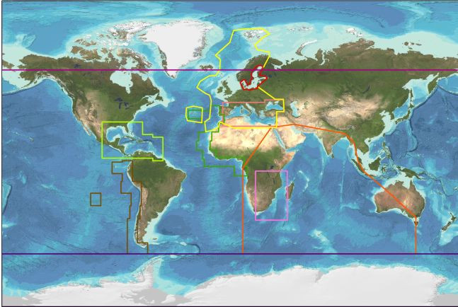
The map below shows the geographic regions covered by some of these projects.
International Bathymetric Chart (IBC) Regional Mapping Projects
GEBCO has long benefitted from contributions from the work of the IBC mapping projects. Find out more about the individual projects:
- International Bathymetric Chart of the Arctic Ocean (IBCAO)
- International Bathymetric Chart of the Southern Ocean (IBCSO)
- International Bathymetric Chart of the Caribbean Sea & Gulf of Mexico (IBCCA)
- International Bathymetric Chart of the Central Eastern Atlantic (IBCEA)
- International Bathymetric Chart of the Mediterranean (IBCM)
- International Bathymetric Chart of the South Eastern Pacific (IBCSEP)
- International Bathymetric Chart of the Western Indian Ocean (IBCWIO)
International Hydrographic Organization (IHO) regional coordination work
The main aims of the IHO Inter-Regional Coordination Committee (IRCC) are to establish, coordinate and enhance cooperation in hydrographic activities amongst IHO Member States on a regional basis and between regions. At the regional level, the Regional Hydrographic Commissions (RHCs) coordinate hydrographic activity and cooperation. The RHCs are made up of IHO Member States together with other regional States that wish to participate. Find out more about the work of these groups.
Further information about the work of these groups and the geographic coverage of the RHCs can be found at the links below.
Regional Hydrographic Commissions
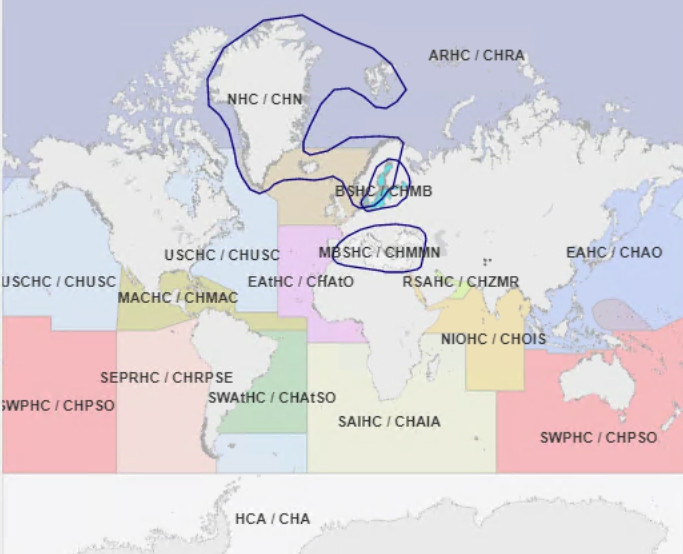
The image below shows the coverage of the RHC’s. When possible, a representative from GEBCO attends their meetings.
Through the Nippon Foundation-GEBCO Seabed 2030 Project, we are working to map the global seafloor by 2030. The graphics below show the percentage of the RHC regions that are considered mapped, according to the criteria defined by Seabed 2030. Find out more about how we are defining what is mapped from the Seabed 2030 Road map.
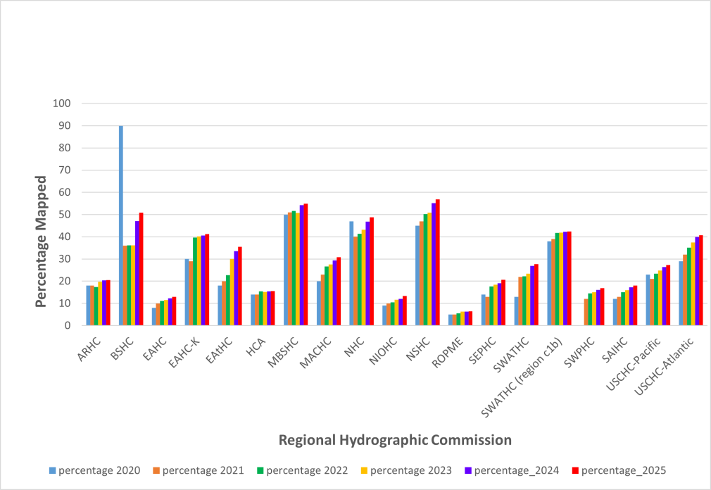
The graphic above, and the table below, show the percentage of seafloor mapped for each RHC region based on the GEBCO grid and Seabed 2030 resolution goals.
Please note that there is a ‘reduction’ of the percentage coverage mapped between 2020, 2021 and 2022 for some RHC areas. This is largely caused by a refinement of our calculations for areas based on pre-generated grids. For some regions, these sections were classed as ‘mapped’ in the GEBCO Grid but for later grid releases it has been possible to break these areas down and identify cells within a pre-generated grid that are based on measured data and those that are based on interpolation. This has resulted in a reduction in the reported percentage coverage mapped for these areas but more accurately reflects to actual observational coverage.
| RHC region | Abbreviation | Percentage of the region mapped based on GEBCO 2020 | Percentage of the region mapped based on GEBCO 2021 | Percentage of the region mapped based on GEBCO 2022 | Percentage of the region mapped based on GEBCO 2023 | Percentage of the region mapped based on GEBCO 2024 | Percentage of the region mapped based on GEBCO 2025 |
|---|---|---|---|---|---|---|---|
| Arctic | ARHC | 18 | 18 | 17.4 | 19.7 | 20.34 | 20.55 |
| Baltic sea | BSHC | 90 | 36 | 36.2 | 36.2 | 47.14 | 50.9 |
| East Asia HC | EAHC | 8 | 10 | 11.2 | 11.6 | 12.32 | 12.99 |
| East Asia region K | EAHC-K | 30 | 29 | 39.6 | 40.1 | 40.54 | 41.29 |
| Eastern Atlantic HC | EAtHC | 18 | 20 | 22.7 | 30.0 | 33.54 | 35.44 |
| IHO HC on Antarctica | HCA | 14 | 14 | 15.4 | 15.2 | 15.49 | 15.54 |
| Mediterannean & Black Sea | MBSHC | 50 | 51 | 51.6 | 50.7 | 54.23 | 54.9 |
| Meso American & Carribean Sea | MACHC | 20 | 23 | 26.6 | 27.6 | 29.32 | 30.84 |
| Nordic HC | NHC | 47 | 40 | 41.4 | 43.2 | 46.85 | 48.72 |
| North Indian Ocean RH | NIOHC | 9 | 10 | 10.5 | 11.7 | 12.11 | 13.35 |
| North Sea RHC | NSHC | 45 | 47 | 50.2 | 50.8 | 55.16 | 56.84 |
| ROPME Sea | ROPME | 5 | 5 | 5.6 | 6.3 | 6.34 | 6.47 |
| South East Pacific RHC | SEPHC | 14 | 13 | 17.7 | 18.4 | 19.04 | 20.65 |
| South West Atlantic HC | SWATHC | 13 | 22 | 22.2 | 23.4 | 26.87 | 27.66 |
| South West Atlantic HC, region c1b | SWATHC | 38 | 39 | 41.8 | 41.9 | 42.27 | 42.35 |
| South West Pacific HC | SWPHC | 12 | 14.5 | 15.1 | 16.06 | 16.91 | |
| Southern Africa & Islands HC | SAIHC | 12 | 13 | 15.1 | 15.9 | 17.27 | 17.98 |
| US Canada, HC Pacific | USCHC-Pacific | 23 | 21 | 23.4 | 24.8 | 26.44 | 27.29 |
| US/Canada, HC Atlantic | USCHC-Atlantic | 29 | 32 | 35.1 | 37.5 | 39.88 | 40.77 |
Crowd-sourced Bathymetry Working Group
As an outcome of the Extraordinary International Hydrographic Conference 5, the IHO Inter-Regional Coordinating Committee has established a Crowd-Sourced Bathymetry Working Group (CSBWG).
The working group will examine how best to incorporate, manage and use bathymetric data collected by other than conventional means and develop principles and guidelines to enable the appropriate collection and use of crowd-sourced bathymetry for the benefit of all stakeholders interested in knowing the shape and nature of the seafloor and its depths.
GEBCO's regional mapping projects
When needed, GEBCO will initiate its own regional bathymetric mapping projects, drawing on the expertise and regional knowledge of local experts including GEBCO colleagues and in particular the GEBCO/Nippon Foundation Scholars.
GEBCO/Nippon Foundation Indian Ocean Bathymetric Compilation (IOBC) Project
The aims of this multinational project are to:
- assemble, collate, archive and publish all publicly-available bathymetric data from all sources within the Indian Ocean
- produce a new bathymetric map and grid of the Indian Ocean (north of 60°S) using data from all available sources
The project will be undertaken by a combination of GEBCO/Nippon Foundation Scholars and other GEBCO members, guided by an Editorial Board.
The map and grid will be developed from scientific cruise data obtained in both shallow and deep water, combined with hydrographic survey data in shallow water as required to complete the map area at the highest resolution possible. Find out more from the project’s web site.
Other collaborative projects
European Marine Observation and Data Network (EMODnet) Bathymetry
EMODnet is a project, funded by the European Commission, to bring together marine data into interoperable, continuous and publicly available data sets for complete maritime basins in European waters.
As part of this project, the EMODnet Bathymetry portal provides bathymetry data in the form of Digital Terrain Models (DTM) for selected maritime basins. The DTMs have been produced from collated bathymetric data sets that are integrated into a central DTM. In regions where high resolution DTMs are not available, bathymetry data is taken from the GEBCO 30 arc-second grid to provide a complete bathymetric model for the region.
Through a collaboration with the EMODnet Hydrography team, GEBCO’s global bathymetric grid includes bathymetry data from the DTMs provided through the EMODnet bathymetry portal.
Baltic Sea Bathymetry Database (BSBD)
The Baltic Sea Bathymetry Database (discontinued) was an effort to generate and make available a bathymetric grid for the Baltic Sea region using data from Baltic Sea countries' national hydrographic offices under the umbrella of the Baltic Sea Hydrographic Commission.
The dataset can still be downloaded from the BSHC web site: https://www.bshc.pro/data/
