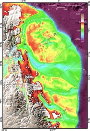
A new digital bathymetric model (DBM) for the northeast Greenland continental shelf (74°N – 81°N) has been released. Find out more about the data set from the accompanying paper:
To help with this task we are encouraging the global community to join in. Through crowdsourcing initiatives, i.e. working with people who are already collecting data we hope to be able to work towards 'mapping the gaps'.
Arndt, J. E., W. Jokat, B. Dorschel, R. Myklebust, J. A. Dowdeswell, and J. Evans (2015), A new bathymetry of the Northeast Greenland continental shelf: Constraints on glacial and other processes, Geochem. Geophys. Geosyst., 16, doi:10.1002/2015GC005931.
Access the data set from PANGAEA.
The DBM has a grid cell size of 250 m × 250 m and includes bathymetric data from 30 multibeam cruises, more than 20 single-beam cruises and first reflector depths from industrial seismic lines.
The new model improves the bathymetric portrayal of the seafloor in this region compared to older models. The DBM not only allows a better delineation of previously known seafloor morphology but also reveals the presence of previously unmapped morphological features including glacially derived troughs, fjords, grounding-zone wedges and lateral moraines.


