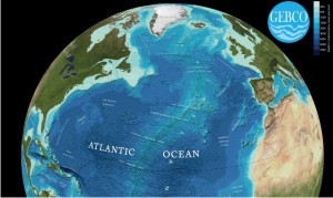
The seafloor consists of deep basins, vast mountain chains and long ocean trenches. This landscape impacts on our everyday lives — it helps to steer ocean currents that in turn affects our climate and influences hazards facing coastal communities like approaching tsunamis.
Images are now available showing the shape of the seafloor.
They have been produced from GEBCO's latest bathymetric grid — the GEBCO_08 Grid, this is a global terrain model at 30 arc-second intervals. The images include the names of features on the seafloor taken from the GEBCO Gazetteer of Undersea Feature Names.
The visualizations were created by Martin Jakobsson of Stockholm University, Sweden, using IVS 3D's Fledermaus software.
The imagery for the land areas is largely taken from the Blue Marble Next Generation data set produced by Reto Stöckli, the US National Aeronautical and Space Administration's (NASA) Earth Observatory (NASA Goddard Space Flight Center).


