
The goal of the IBCAO initiative is to develop a digital data base that contains all available bathymetric data north of 64° North, for use by mapmakers, researchers, institutions, and others whose work requires a detailed and accurate knowledge of the depth and the shape of the Arctic seabed.
The IBCAO data set is included, as a regional compilation, in the global GEBCO grid.
Version 5 of the data set is now available - released in 2024.
Access the release paper for Version 5 of the IBCAO to find out more about the development of the data set. Jakobsson, M., Mohammad, R., Karlsson, M. et al. The International Bathymetric Chart of the Arctic Ocean Version 5.0. Sci Data 11, 1420 (2024). https://doi.org/10.1038/s41597-024-04278-w.
Find out more about the IBCAO project.
Access the IBCAO V4 release paper published in the Nature Journal, Scientific Data.
Download the grid files
The data are made available in Polar Stereographic projection co-ordinates (meters), EPSG:3996, true scale set at 75°N. The horizontal datum for the data set is WGS 84 and vertical datum can assumed to be Mean Sea Level (however, note there may be datum issues for older data, which can be to chart datum). Elevation values are in meters (floating point).
Downloading data indicates that the user accepts the disclaimer information.
Contact the Nippon Foundation-GEBCO Seabed 2030 Arctic and North Pacific Regional Center for more information about the data sets ( arctic-pacific@seabed2030.org ).
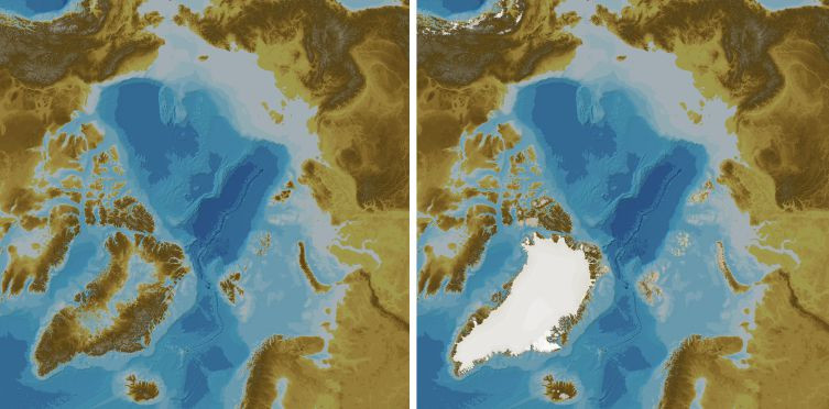
Without elevation data for the Greenland Ice Sheet
| 100mx100m grid cell spacing | |||
|---|---|---|---|
| As a single complete bathymetric grid | |||
| GeoTiff format (11.4 Gbytes, 13.5 Gbytes uncompressed) | |||
| As a set of 16 tiles | |||
| GeoTiff format (11.4 Gbytes, 13 Gbytes uncompressed) |
| 200mx200m grid cell spacing | |||
|---|---|---|---|
| As a single complete bathymetric grid | |||
| GeoTiff format (3 Gbytes, 3.3 Gbytes uncompressed) |
| 400mx400m grid cell spacing | |||
|---|---|---|---|
| As a single complete bathymetric grid | |||
| GeoTiff format (1 Gbytes, 1 Gbyte uncompressed) |
Data set disclaimer information
With elevation data for the Greenland Ice Sheet
| 100mx100m grid cell spacing | |||
|---|---|---|---|
| As a single complete bathymetric grid | |||
| GeoTiff format (11.4 Gbytes, 13.5 Gbytes uncompressed) | |||
| As a set of 16 tiles | |||
| GeoTiff format (11.4 Gbytes, 13 Gbytes uncompressed) |
| 200mx200m grid cell spacing | |||
|---|---|---|---|
| As a single complete bathymetric grid | |||
| GeoTiff format (3 Gbytes, 3.3 Gbytes uncompressed) |
| 400mx400m grid cell spacing | |||
|---|---|---|---|
| As a single complete bathymetric grid | |||
| GeoTiff format (1 Gbytes, 1 Gbyte uncompressed) |
Data set disclaimer information
100mx100m Data Type Identifier Grid
This data set identifies the type of data that a grid cell is based on. It follows the TID coding as used for the GEBCO global grid.
| GeoTiff format (0.3 Gbytes, 3.3 Gbytes uncompressed) |
100mx100m Source Identifier Grid
This data set identifies the source of data that a grid cell is based on.
| GeoTiff format (0.7 Gbytes, 6.7 Gbytes uncompressed) |
Data set disclaimer information
Historical IBCAO data sets
Previous versions of the IBCAO grid are available from our Regional Mapping section.
Disclaimer information
Version 5 of the International Bathymetric Chart of the Arctic Ocean (IBCAO) Grid, now referred to as the 'IBCAO V5 Grid', available from the above links, is provided on behalf of the IBCAO project under the terms of the disclaimer information as given below.
The IBCAO V5 Grid, should NOT be used for navigation or for any other purpose involving safety at sea.
The IBCAO V5 Grid is made available 'as is'. While every effort has been made to ensure reliability within the limits of present knowledge, the accuracy and completeness of The IBCAO V5 Grid cannot be guaranteed.
No responsibility can be accepted by those involved in its creation or publication for any consequential loss, injury or damage arising from its use or for determining the fitness of The IBCAO V5 Grid for any particular use.
The IBCAO V5 Grid is based on bathymetric data from many different sources of varying quality and coverage.
As The IBCAO V5 Grid is an information product created by interpolation of measured data, the resolution of the IBCAO V5 Grid may be significantly different to that of the resolution of the underlying measured data.
Find out more
Contact the Nippon Foundation-GEBCO Seabed 2030 Arctic and North Pacific Regional Center for more information about the data sets ( arctic-pacific@seabed2030.org ).